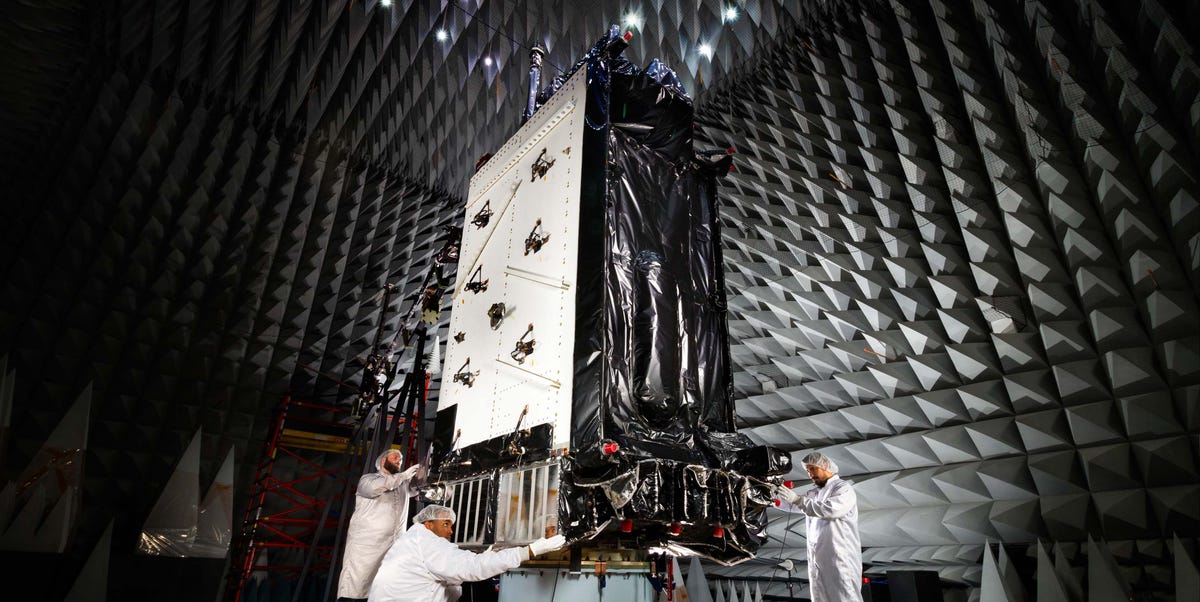
GPS is one of those technologies we use so often that we forget it is not magic. Your phone does not simply “know” where the nearest taco truck is because it has achieved spiritual enlightenment. It is listening to atomic-clock signals from satellites thousands of miles above Earth, doing math at ridiculous speed, and turning spaceborne timing into a blue dot on a map.
That is why the U.S. military’s next-generation GPS satellites matter. The title says “USAF” because the modernization story began under the U.S. Air Force, but today the Global Positioning System is operated and maintained by the U.S. Space Force. The mission, however, remains the same: keep positioning, navigation, and timing reliable for troops, pilots, ships, emergency responders, farmers, engineers, and ordinary drivers who still somehow miss exits with turn-by-turn directions yelling at them.
The coming GPS III Follow-On satellites, commonly called GPS IIIF, promise better resilience, stronger anti-jam capability, improved support for civilian aviation, search-and-rescue payloads, laser reflectors, and military features designed for a world where electronic warfare is no longer a side dish. The upgrade is real. The catch is also real: satellites, ground-control software, and military receiver programs all have to mature together. In other words, the future of GPS is bright, but it may arrive wearing government-issued boots and walking at a careful pace.
Why GPS Modernization Is Such a Big Deal
GPS is more than a navigation convenience. It is a national infrastructure system hiding in plain sight. Banking networks use precise timing. Power grids depend on synchronization. Cell towers, shipping ports, aviation systems, farm equipment, emergency services, and military units all rely on accurate positioning, navigation, and timing, often shortened to PNT.
The original GPS architecture was revolutionary, but the world around it has changed. Jamming and spoofing have become more common. Smartphones now use multi-constellation navigation, drawing from GPS, Galileo, GLONASS, BeiDou, and regional systems. Commercial users want more accuracy. Military users need signals that can survive contested environments. Civil aviation needs reliability that does not go on vacation when the atmosphere gets moody.
That is where GPS modernization comes in. The broader effort replaces older satellites, introduces new civil signals such as L2C, L5, and L1C, improves military M-code capability, and upgrades the control segment that commands and monitors the constellation.
From GPS III to GPS IIIF: The Next Step
GPS III satellites already marked a major leap over older spacecraft. They were designed for longer service life, better signal accuracy, stronger resistance to jamming, and a new L1C civil signal intended to improve compatibility with other global navigation satellite systems. GPS III also brought M-code, the modern encrypted military GPS signal designed to help U.S. and allied forces operate in hostile electromagnetic environments.
GPS IIIF is the follow-on generation. Think of GPS III as the new phone and GPS IIIF as the version with the better camera, stronger battery, and fewer reasons to yell at customer support. GPS IIIF is expected to build on the GPS III design while adding features that matter in both civilian and military contexts.
Regional Military Protection
The headline feature is Regional Military Protection, or RMP. This capability is designed to concentrate higher-power M-code coverage over specific regions, helping military users maintain access to GPS in areas where adversaries are trying to jam or deny signals. In simple terms, GPS IIIF is expected to bring more muscle to the places where GPS is under the most pressure.
Better Civilian Support
GPS IIIF is also expected to support a stronger civil signal environment. Modern civil signals such as L5 and L1C are important for aviation, transportation, surveying, mapping, and high-performance receivers. L5 is especially important because it sits in an aviation-protected frequency band and is designed for safety-of-life applications. For pilots, rail systems, ships, and advanced vehicles, “slightly better signal” can translate into safer routing, better redundancy, and fewer operational headaches.
Search and Rescue Payloads
Each GPS IIIF satellite is planned to include a search-and-rescue payload. That matters because GPS satellites have global reach and medium Earth orbit coverage. Adding rescue-related payloads to navigation satellites is like asking a very punctual mail carrier to also keep an eye out for distress calls. It does not replace dedicated emergency systems, but it can strengthen the global safety net.
Laser Reflectors and More Precise Satellite Tracking
GPS IIIF satellites are also expected to carry laser retroreflector arrays. These allow ground stations to refine satellite position using laser ranging. More precise knowledge of where a satellite is helps improve the quality of the navigation signals users receive. GPS is a timing system wearing a navigation costume, and even tiny improvements in orbital knowledge can matter.
The Upgrade Sounds Simple. It Is Not.
Here is the part where the story gets less glamorous and more Pentagon spreadsheet. A GPS satellite does not become useful just because it reaches orbit. It must be launched, checked out, commanded, monitored, integrated into the constellation, and supported by receivers that can actually use its new signals.
That means the space segment, control segment, and user equipment must line up. If one piece is late, the whole orchestra starts sounding like a middle-school band warming up in a gymnasium. The satellite may be ready, but the ground system may not be. The signal may exist, but older receivers may not be able to use it. The military feature may be impressive, but operational testing may lag behind launch schedules.
This is the heart of the “eventually” in the headline. The satellites are a huge upgrade. The benefits will arrive in phases.
The Ground-Control Problem: OCX and the Detour Back to AEP
The biggest complication has been the GPS ground-control system. The Next Generation Operational Control System, or OCX, was supposed to replace older control systems and unlock the full potential of GPS III and future GPS IIIF satellites. It was meant to provide more secure command and control, improved cybersecurity, support for modern signals, and the ability to operate the modernized constellation more effectively.
Instead, OCX became one of those defense acquisition stories that makes budget analysts reach for coffee by the gallon. After years of delays, technical issues, cost growth, and testing problems, the U.S. Space Force terminated the OCX program in April 2026. Officials said the program could not deliver the needed capabilities on an operationally relevant timeline at an acceptable level of risk.
That does not mean GPS stops working. Far from it. The Space Force has spent years improving the existing Architecture Evolution Plan, or AEP, ground system. AEP has been upgraded to support many GPS modernization needs and will continue to be enhanced. But the cancellation of OCX changes the modernization path. Instead of moving cleanly to a shiny new control system, the Space Force is now leaning harder into incremental upgrades to what already works.
That approach may be less glamorous, but it has a certain practical charm. If the futuristic control system refuses to behave, maybe the best move is to improve the reliable older system until it can carry the load. It is not flashy. It is not the movie trailer version of space modernization. But it may be the adult-in-the-room solution.
What GPS IIIF Means for the Military
For the military, GPS IIIF is not about helping someone find a coffee shop. It is about keeping forces synchronized, positioned, and coordinated in environments where enemies are actively trying to blind them.
Modern warfare depends on precision. Aircraft, ships, ground vehicles, missiles, drones, logistics networks, and command systems all need reliable PNT. When GPS is jammed or spoofed, the problem is not merely inconvenience. Units can lose timing, weapons can lose accuracy, and commanders can lose confidence in the location of friendly forces.
M-code and Regional Military Protection are designed to make GPS more survivable in that environment. RMP’s promise is especially important because it focuses power where the threat is highest. Instead of treating the entire planet the same way, GPS IIIF can support a more targeted approach for military operations.
But again, the satellite is only part of the chain. Military users need M-code-capable receivers. Aircraft, ships, vehicles, handheld devices, and weapons platforms must be upgraded, tested, certified, and fielded. That takes time. A powerful satellite signal does not help much if the receiver on the ground is still living in the technological equivalent of 2009.
What GPS IIIF Means for Civilians
Civilians may not notice GPS IIIF in the dramatic way they notice a new phone model. There will probably not be a launch-day moment when everyone’s blue dot suddenly becomes emotionally supportive and perfectly accurate indoors. The benefits will be more gradual.
Still, the civilian upside is substantial. New civil signals can improve accuracy, reliability, and resilience, especially for professional users. Surveyors, construction firms, farmers using precision agriculture, aviation operators, maritime services, timing-dependent industries, and emergency responders can all benefit from a more modern GPS constellation.
L5 is particularly important for transportation safety because it is designed for high-performance and safety-of-life applications. L1C matters because it improves interoperability with other global navigation systems. When receivers can combine multiple signals and constellations, users get better performance in challenging environments such as cities, mountains, forests, and areas with interference.
For the average user, the change may feel quiet. Your map may load faster, your device may hold location better, and your apps may become more reliable in tricky places. The best infrastructure upgrades often work that way: they are successful when nobody has to think about them.
Why Jamming and Spoofing Make the Upgrade Urgent
GPS signals are weak by the time they reach Earth. That is not a design flaw so much as a physics reality. The satellites are far away, and their signals arrive at very low power. A jammer on or near the ground can overpower those signals in a local area. Spoofing is even sneakier: instead of simply blocking GPS, it feeds receivers false information.
In civilian life, interference can disrupt aviation, shipping, agriculture, telecommunications, and timing systems. In combat, it can create chaos. This is why anti-jam capability is no longer a nice bonus. It is central to the future of GPS.
GPS IIIF’s anti-jam improvements, especially for military users, reflect a larger reality: space systems are now part of contested warfare. Satellites are not just helpful assets floating peacefully overhead. They are targets, enablers, and strategic pressure points. The Space Force has to think not only about building better satellites but also about defending the services those satellites provide.
The Launch Timeline: Why “Eventually” Still Belongs in the Title
GPS IIIF satellites are in production, but schedules have shifted. Public reporting and official statements have pointed to first launches in the late 2020s, with some updates indicating launches as early as 2028. The exact timing depends on satellite readiness, launch availability, ground-control upgrades, testing, and the broader GPS enterprise plan.
This is not unusual for major space programs. Satellites must survive vibration, vacuum, thermal testing, integration, and launch. Ground systems must be certified. Receivers must be fielded. Operational commanders must trust the new capability. A GPS satellite is not a gadget you unbox; it is part of a global service that must be reliable every second of every day.
The “eventually” is not a joke at the expense of engineers. It is a reminder that national infrastructure modernization is hard. GPS is like replacing the wiring in a skyscraper while every tenant is still using the elevators, Wi-Fi, bank vault, security cameras, and coffee machines.
How the GPS Upgrade Fits Into the Bigger Space Race
The United States is not modernizing GPS in a vacuum. Other global navigation satellite systems have matured quickly. Europe’s Galileo offers modern civil signals. China’s BeiDou has become a major global system. Russia’s GLONASS remains strategically important. Japan and India operate regional navigation systems. The result is a crowded GNSS world where interoperability, resilience, and trust matter more than ever.
For U.S. leadership, GPS IIIF is about staying ahead. The system must remain reliable for allies and attractive for global users. It must support commercial innovation and national defense at the same time. That is a difficult balancing act, but GPS has always been a strange and powerful hybrid: a military system that became one of the most important civilian technologies on Earth.
The Practical Bottom Line
USAF’s next-gen GPS satellitesnow more accurately a U.S. Space Force GPS IIIF effortwill be a major upgrade. They promise stronger military protection, better resilience, improved civil signal support, search-and-rescue enhancements, and more precise satellite tracking. They also arrive at exactly the right moment, when GPS interference is becoming a more serious concern for both military and civilian users.
But the upgrade is not instant. Ground systems, receiver modernization, testing, and launch schedules remain critical. The cancellation of OCX makes the path more complicated, but it does not cancel the future of GPS. Instead, it forces the Space Force to modernize in a more incremental, practical way.
That may not sound as dramatic as “brand-new space control system transforms everything overnight,” but it may be more realistic. And with GPS, realistic is good. Nobody wants the global timing and navigation system to be run like a beta app with patch notes that say, “Known issue: satellites sometimes confused.”
Experience-Based Reflections: What This Upgrade Feels Like in Real Life
To understand why GPS IIIF matters, it helps to think about everyday experiences with GPS. Most people only notice GPS when it fails. When it works, it is invisible. When it does not, suddenly everyone becomes an amateur satellite engineer standing in a parking lot, waving a phone at the sky as if the device needs encouragement.
Anyone who has driven through a dense downtown area has seen the blue dot drift, jump, or confidently place the car inside a building. That happens because tall structures block and reflect satellite signals. A navigation app may recover quickly, but professional users cannot always shrug it off. A delivery fleet, emergency response team, survey crew, or autonomous system needs better reliability than “close enough, probably.” Modern GPS signals and multi-frequency receivers can reduce those errors and make positioning more dependable.
There is also the aviation experience. Passengers rarely think about satellite navigation during a flight, which is ideal because passengers already have enough to worry about, including armrest diplomacy and whether the person in front will recline during meal service. But modern air traffic increasingly depends on satellite-based navigation. Stronger civil signals such as L5 can support safer and more efficient flight operations when fully available and integrated into certified systems.
Farmers using precision agriculture offer another practical example. GPS-guided tractors, sprayers, and harvesters can reduce overlap, save fuel, improve yields, and apply inputs more accurately. In that world, better positioning is not a luxury. It affects costs, efficiency, and environmental impact. A stronger GPS constellation helps make high-precision work more reliable across large fields and remote areas.
Emergency responders also stand to benefit. Search-and-rescue payloads on GPS IIIF satellites may strengthen the global distress-alerting ecosystem. In a rescue scenario, minutes matter. A better satellite network can help responders detect and locate distress signals more effectively. Nobody wants to need that capability, but everyone should want it to exist.
Military experience is even more demanding. Imagine operating in an environment where the adversary knows your forces depend on GPS and is actively trying to interfere with it. Navigation, timing, communications, targeting, and logistics can all be affected. In that setting, anti-jam capability is not a technical footnote. It is mission survival. GPS IIIF’s Regional Military Protection is designed for exactly that kind of pressure.
The most important lesson from the GPS IIIF story is that infrastructure progress often feels slow until it suddenly becomes indispensable. The first time a new signal improves safety, keeps a formation synchronized, helps a rescue team locate someone, or lets a pilot maintain confidence in a difficult environment, the years of engineering and testing look less like delay and more like preparation.
GPS is a quiet miracle, but it is not self-sustaining. It requires satellites, launch vehicles, ground stations, software, receivers, operators, cybersecurity, funding, and political patience. GPS IIIF is a reminder that the invisible systems we trust every day need continuous investment. The upgrade may arrive gradually, but when it does, it will touch far more than maps. It will strengthen the timing and navigation backbone of modern life.
Conclusion
USAF’s next-gen GPS satellites will be a huge upgrade, even if the full payoff arrives in stages. GPS IIIF is designed for a tougher world: one with more jamming, more spoofing, more dependence on timing, and more demand for accurate navigation. Its Regional Military Protection capability, improved civil signal support, laser reflectors, and search-and-rescue payloads make it one of the most important GPS modernization steps yet.
The only honest caveat is that satellites alone do not modernize GPS. Ground systems, user receivers, testing, and operational fielding must catch up. The end of OCX adds complexity, but the Space Force’s shift toward improving existing control systems may prove to be the practical path forward. GPS IIIF is coming, and when its capabilities are fully available, the upgrade will matter to warfighters, pilots, first responders, industry, and anyone who has ever trusted a tiny blue dot to get them home.